
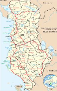
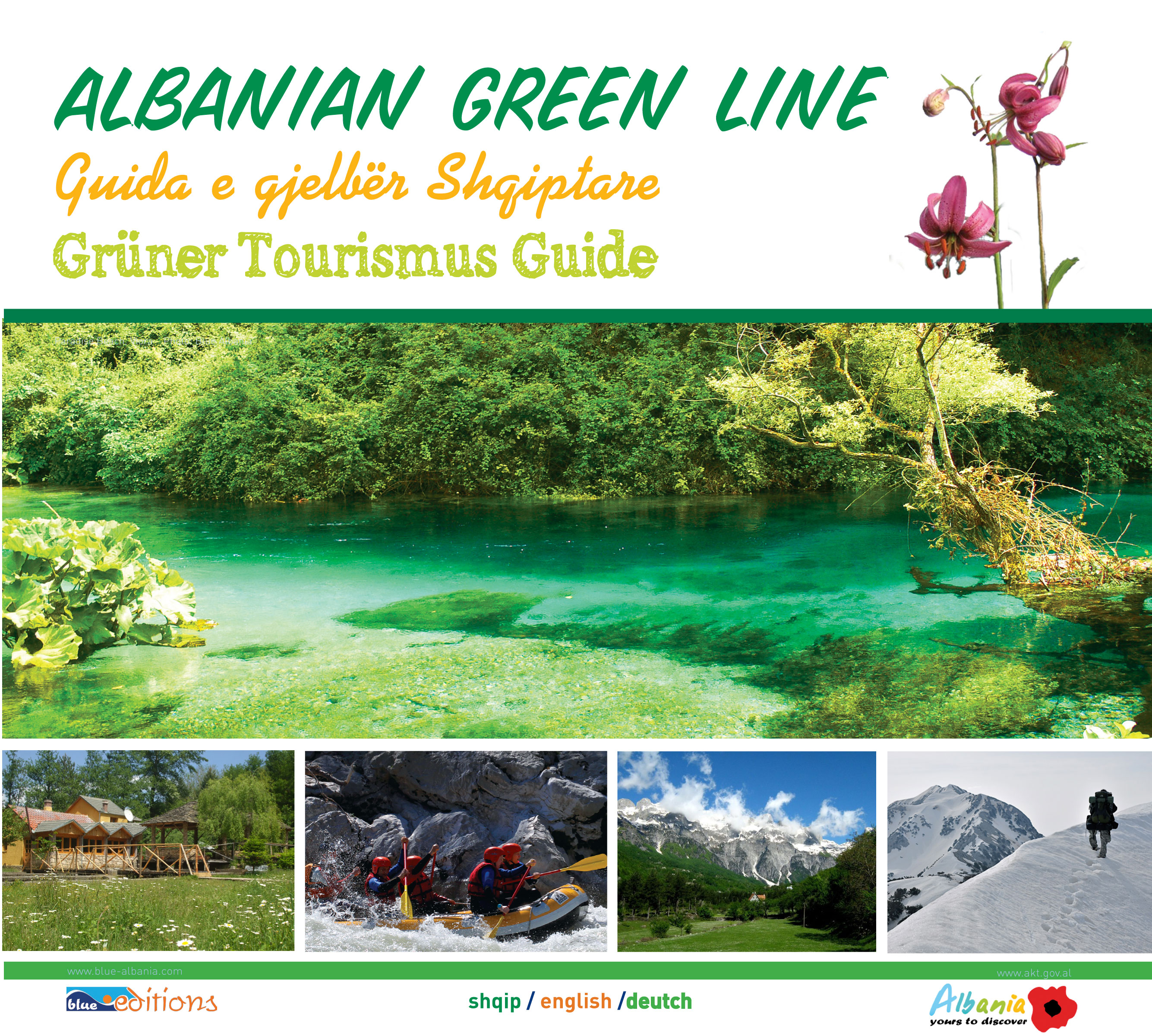
Albanian Map
Links
 |
Publications
.jpg)


Shkodra General Info
.jpg)
Shkodra is one of the largest and most important cities of Albania and lies in the northwest part of the country. It is also the biggest trade center of the North. Being one of the most ancient cities too, was established in the last millennium B.C. as the capital city of the Illyrian tribe of the Labeates. It was a very developed economic centre, under the leading of King Agron and Queen Teuta. During that period, the city lied from Shkodra Lake, till in the Kotorri Bay.
Visiting Shkodra means to give to onself the privilege to touch the ancient history of Albania, its culture which comes from the deep times, its geography, rare and marvellous, the fine humor, the charcateristic hospitality and the funny people.
Being one of the most ancient cities in Albania, Shkodra has given to its country, many personalities of history and culture, during all the periods. Shkodra is called very early, the cradle of the culture.
History
Shkodër was founded around the 4th century BC. This was the site of the Illyrian tribe Labeates as well as the capital of the kingdom of King Gentius and that of Queen Teuta.
The dawn of the Middle Ages saw waves of Slavs arriving. De Administrando Imperio describes how Byzantine Emperor Heraclius gave the Slavs the city of Shkodër and the surrounding territories during the first half of the 7th century.
The Byzantines later incorporated the region directly into their empire, forming the Theme of Serbia governed by Strategos Constantine Diogenes. After numerous dynastic struggles, in the 12th century Shkodër became a part of Zeta, which was a part of medieval Serbia. It later fell to the hands of the House of Balši? followed afterwards by the Dukagjini control who surrendered the city to the Venetian rule, forming a coalition against the Ottoman Empire with many neighboring Albanian tribes. 15th to 19th centuries
Shkodër (under Venetian rule) resisted a major Ottoman attack in 1474. In 1478 the city was again entirely surrounded by Ottoman forces. Mehmed the Conqueror personally laid the siege.
Shkodër played an important role during the League of Prizren, the Albanian liberation movement.
During the Balkan Wars, Shkodër went from one occupation to another, when the Ottomans were defeated by the Kingdom of Montenegro.
During World War I, Montenegrin forces again occupied Shkodër on June 27, 1915. In January 1916, Shkodër was taken over by Austria-Hungary and was the center of the zone of their occupation. After World War I, the international military administration of Albania was temporarily located in Shkodër, and in March, 1920, Shkodër was put under the administration of the national government of Tirana.
Shkodër was the seat of a Catholic archbishopric and had a number of religious schools. The first laic school was opened here in 1913, and the State Gymnasium was opened in 1922. It was the center of many cultural associations. In sports Shkodër was the first city in Albania to constitute a sports association, the "Vllaznia" (brotherhood). Vllaznia is the oldest sport club in Albania.
During the early 1990s, Shkodër was once again a major center, this time of the democratic movement that finally brought to an end the communist regime established by Enver Hoxha.
Cultural inheritage
The cultural inheritance for the zone of Shkodra starts from the XV-th century with the first scripts in Albanian language. In this city lived the most conspicuous historians, writers, illuminators, etc. In the XVIII-XIX-th centuries started to build the first state institutions which represent the connections of Shkodra with the civilian world of Europe. For the first time in Albania is developing the culture, sport, the art of photography, museums, libraries, publishing house, and later on, the cinema and electric power. Including tradition, Shkodra is one of the most conspicuous cities which represents the Albanian culture.
Special geography
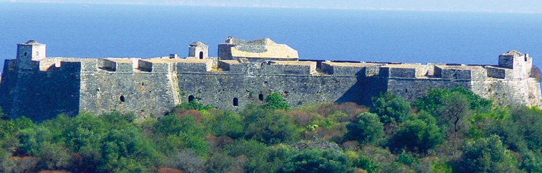
Situated between three rivers, Drini, Buna and Kiri, the Lake, the Mountain of Taraboshi and especially the unrepeated castle of Rozafa, Shkodra has always been wanted and attacked from many invaders since in the first periods of its establishment.
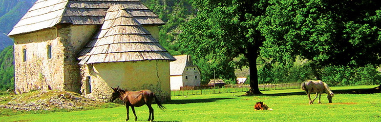
The city has a very interesting architecture, with wide roads, and houses surrounded by high stone walls and big front doors made of wood. The most attractive sight of it, is with no doubt the castle of Rozafa which is located to the west and surrounded by the Drini and Buna rivers.
What to visit
One of the most attractive objects is Rozafa castle, part of the arch The history of the castle begins in times of the Illyrians. An especially gripping legend explains its origins. A woman was sacrificed that the castle could be erected. The woman was a young mother with a little baby. The limy-water that flows from the stones at the main entrance of the castle, relates to the myth of the milk from the breast of Rozafa, the woman who was sacrificed, because she requested one breast to be left uncovered, to feed her baby.
Inside the city, Gjuhadoli and Serreqi, are the oldest and the most characteristic neighborhoods.
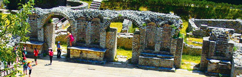
In the county of Shkodra, the remains of the medieval town of Sarda or Shurdhahu, 15 km from the city, are of great tourist and historical interest.
Sarda, a medieval town with an area of 5 ha, established originally on a hilltop, is now transformed in an island in the lake of Vau i Dejës. In earlier times, it was the residence of the great feudal Dukagjini and his family, where they have built they princely palace. The town was surrounded by walls. What has remained nowadays, consists of the main entrance to the palace and a church of Roman architecture. The island of Sarda is a great possibility to grow up the daily tourism.
The bridge of Mes is located above the Kiri River, 6 km from Shkodra in the village of Mesi. It is made of stones and has a unique architecture. The bridge, which is 108 m long, was built in 18th century and consists of 13 stone arches.
Velipoja
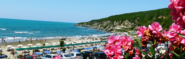
To the southwest lies the beach of Velipoja, famed for the quality of its curative sand. Close by, is the lagoon of Viluni and the alluvial island of Franc Joseph, located in the proximity of the mouth of Buna, all representing particularly attractive ecosystem for those interested in ecotourism and nature lovers in general. Velipoja is the biggest beach in the north of Albania and except the habitants of the North, lastly is visited even by Albanian people who live in Kosovo and Montenegro. They find many reasons to come at Velipoja beach, every summer already. The beach has not only natural beauties but also many hotels and rent apartments with very convenient prices and comfortable contemporary conditions.
Lastly Velipoja has been under constructing works which makes it more favorable for vacationers. The centre of the beach is larger and cleaned from old ugly buildings, and the street is reconstructed along the beach arriving next to the Viluni lagoon.
Choosing Velipoja, for your vacation, means, doing a great healthy gift to yourself, because of the curative sand, fresh air and green zones around.
The lagoon of Viluni
It is one of the biggest lagoons in Albania, next to the beach of Velipoja, rich of plants and animals, which make its ecosystem protected from Albanian authorities. Near of delta of Buna River, lies the island of Franc Joseph, which except the beauties of the nature, is suitable for the ecotourism.
The lake of Shkodra
Is situated at the northeast of Albania, and is the largest lake of Balkan Peninsula
It is part of the boundary with Montenegro, with a surface of 386 km2, in which 149 km2 are situated at the Albanian territory. The longitude is 48 km, latitude 26 km, and deepnes 7-10 m, where the maximum arrives 44 m. Through the river of Buna, this lake runs to the Adriatic Sea. The climate is Mediterranean, with wet rainy winter and hot dry summer.
It has a special system of water with fluctuation of 5 m. The main part of the water comes from the rivers Drini, Kiri and the rest comes from the mountains. The aquatic node Bunë-Drin, plays an important role at the system of the lake.
The lake of Shkodra is surrounded by Shiroka dhe Zogaj at the side of Taraboshi mountain and at the oposite, there are a lot of small villages that, starting from Hanit i Hotit boundary we align: Jubicë, Kamicë-Flakë, Lashaj , Flakë , Brucaj, Kasan, Pjetroshan, Lagej, Aliaj, Premal, Goshaj, Culaj, Koplik, Koplik i Mesëm, Bzhetë-Makaj , Bogic-Palvar Dobër, Sterbeq, Kalldrun. This area is ideal for the green and blue tourism but is still virgin and doesn’t have an available infrastructure. Maybe you can visit theese places to admire the amazing nature waiting fot the development to come.
Shiroka and Zogaj
Not far from the city is the Shkodra Lake. It is the biggest in the Balkan Peninsula and divides the city from Montenegro. Among the lake, lies the beach of Shiroka and Zogaj which are regularly frequented by daily holidaymakers from Shkodra and not only. The numerous restaurants offer the lake menu where dominates the fish. In this zone you will find the most attractive tourist resort, called Marku, which offers you accommodation and a lot of tourist services.
But Shiroka can be visited even with bicycles, according to the old tradition of the habitants of the zone.
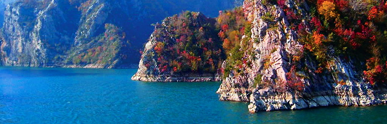
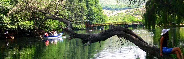
The Lake of Koman
If you want to have an unforgettable voyage through the valleys, canyons and the special landscapes cruise in the Lake Koman, that is 30 km from the city. The lake was formed when the Komani hydropower station (600000 kw/hour was built on the Drini river gathering its water in a lake. Its surface area is 12 km (34.5 km long and 50-60 wide).
The lake is surrounded by forested mountains that rise 1000-1200 m above sea level. This region is well-known for its attrations and the great historical importance. A grave of the yard of the 6-8 century AD, found in the Komani village that is quite close to the lake, throws light upon the ancient Albanian society. Albanian and foreign visitors are offered travel facilities. The ferry-boat carries passengers and goods too.
Vau i Dejës Lake
This lake is in the vicinity of Shkodra. Its surface area is 24.7 km and its maximal depth is 52 m. The lake was formed when the Vau i Dejës hydropower station (250 kw/hour) was built on the Drini river gathering its water in a lake. Its beauty is bewitching.
Everyone feels happy passing through the gorges of the mountains surrounding the lake the forested shores. The carstic phenomens are very attractive. The lake serves for transport, fishing and tourism. in the middle of the lake, is situated the island of Sarda or Shurdhahu, which still kepps the ruins of the medieval period. You can see the traces of a church in medieval architecture style. the islan is ideal for the daily tourism. Lastly the number of the visitors is growing up, and this area has started to offer gastronomic structrures. Bar Restaurant Perla is one of those and offers ecxelent Italian cuisine, also the pizza in wood oven.
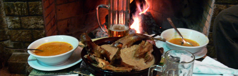
Gastronomy
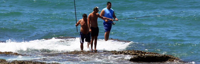
There is a lot of of food, starting from the simple meat-balls, famous in Shkodra, and finishing with the most complicated dishes of Italian cuisine. Naturally the fresh fish is always present in every restaurant. The cuisine is healthy and based on the products of the zone, as fresh fish and meat, accompanied from vegetables of the season.
Entertainment
Certainly the main entertainment is the beach with its endless alternatives for the free time, as walking, swimming, playing and every other kind of small pleasures. At the evening when the hot day is over, have fun, making long walks at the coast or at the center of the beach, where the children can play on the playgrounds.
The night is full of surprises in Velipoja. A lot of night clubs offer live music, inviting famous singers to show their talent followed from numerous funs. The restaurant offer also live music, to complete as well as they can the requests of their costumers.
The National Park of Thethi
Thethi, one of the most special countries in the Albanian Alps, situated at the north part of Shale commune, Shkodra district, is positioned in a hale 700-950 meters over the sea level and it is inhabited permanently.
In 1937 opened a tourist agency. On 18th of July 1956 was created first alpine movement on our country. On 1966 was built a micro central nearly 45kw/h 24kw/n and on 1967 it is implemented an aggregate to threat woody materials. In 1956 was opened a tourist center at the building of hotel, mainly for worker’s holidays and alpinist’s holidays. In 1976 has been praised National Park on 2630 ha and actually is the second national park, After Dajti National Park, according to the size-quantity.
Geographical position
Thethi is positioned in the head of Shala’s Valley and also the Shkodra division/district too.Nature supple a beautiful, fascinated and relaxed view that is so wanted in our day. Thethi Country is composed from teetanic-glacier hides that make it look like a trough/washtub 6km long and 1km width. Lowest level is 700m over sea level. At the North is grey and undressed Arapis Peak 2217.2m over sea level, too much referred from alpinist for its difficulty according to international level. At the East, you must see a wonderful hale where lies Jezerca, 2692m over sea level. Peak of Alise 2471m,peak of Pullaka 2569m,in this port you can climb to peak of Boshi 2471 above Dreri’s peak from where you can see other mountains hill peak of Hekurave 2559.4m and2125.5m.There mountains are positioned one after another like white carter with different forms and glacier and carstic phenomenon. Mountain at the west side of peak of Arapi is peak of Rryshbullit 2431m going dower to peak of Zorgji 1663.8m,peak of Bigos se Gimajve 2230m.From peak of Radonimo could be seen Bjeshket e Namuna and Alps in generally, hill the center mountainous region. A sea of mountains circle Thethi, giving it the beauty of European Alpes. This join is narrowed from rocks to peak of Dren and steeps of Zorgji. In this narrowing is created big canyon of Grunasi with great carbonated formations. It is 2km long with a 76/1km slope, 30-60m deep and 2-3m wide. In side of these rocks are grave of Zorgji, grave Qyqe Ret, grave, grave that is in Thethi the Pepes’s field to old and “Hole of water” to pass of Pea, grave of Arapi and grave of Rratheve which have large digressions and interesting like underground lakes, galleries and siphons of stalactites and stalagmites.
Thethi country cultural attractions beginning with traditional clothes, churches, characteristic houses way of living. Traditional clothes are xhubleta for women and trip and xhamadan (doublet) for men. Women use traditional veil, brides use veils with roses and light colors and other takes black veils tied to the throat. Utilizes even homes of habitants because free and with a small investment could be transformed to very comfortable homes for visitors. There are fields alpine tents can be pitched up. Men use woolen traditional hat called Kesule Characteristic housed are build by stones and their roofs are very sloppy, to slope the snow. They are with 2-3 flat, builds on descents or near the mountains. For these house are characteristic stairs, at the external part of the house, that bring you to the second flat because the first flat is usually used for animals. In the second flat is guest’s room & rooms for other members of family. That’s what can bear Lulash Keqi’s house in a perfect way. The tower with 3 flats, wooden roof, very small window just to air the tower, it has no stairs only one door this kind of tower was used from wan one kin, to be protected, when they had conflicts with one or more kins. There live only men of the kind from which must revenge. They live there till the oldest members of the country interfere to solve the conflict. Men in the tower were nourished from woman towards them was not permitted to revenge. In 1892, based on documents, Thethi is known like parson. The first person to Thethi’s church was an Italian called in Findez. P. Gabrielda Danga who died and buried inside Thethi’s church this years. It is said that in this country was found a bell from the period of Turkish conquests. Habitants has the bell to the groves underground where is spoken for this bell generation after generation. The way of living and the position of houses at strategic parts protected from natural factors and in suitable parts of living like: near sources and agricultural land.
Another characteristic is that roads in the country are separate for people and for animal. They are
surrounded by walls made with stones or by hedge. New that automobilist road is open their utilization
have changed a bit.
The natural monuments.
Geo-monuments
The Olistolites of Tepe. Located in the hills near Shkodra. There are two blocks of limestone Alps in a tectonic zone, located on Paleogenic, flisch, 10-15 m of height. There are scientific values geological, didactic and tourist ones. It has been studied by Prof. V. Melo and Prof. A. Hyseni. Can visited by the road to the Castle of Rozafa.
The tectonic rupture of Shkodra. Situated near the village of Shiroka, It is distinguished first by Austrian geologist Franz Nopcsa, before XX-th century. Can be visited by the road to bridge Buna-Shiroka.
The fragment of tectonic rupture Shkodra-Peja. It is almost the largest tectonic rupture in the Albanian territory, from Shkodra in Peja. Under it is the tectonic contact with flisch ophiolites of Krasta-Cukali. Its reactivation brings earthquakes. There is geological scientific values. Can be visited following the itinerary Vau i Dejes, Koman.
The Black stone. Situated near the village of Guri i Zi, about 42 m above sea level. Between flysch represents magmatic rock, coming from the top slope, with an extended shape of 100-120 m, width 20-30 height 80-10 m. There are scientific values, geological didactic and tourist ones. Can be visited following the itinerary Shkodër-Guri i Zi.
Slab of Palaj. Located near the village, municipality of Shosh. It represents rocky limestone, scaled, about 1 km long, 200 m altitude, with the carst caves.
It has scientific values, geological didactic and tourist ones. Can be visited following the itinerary Shkodër-Shosh-Palaj.
The stone of Leka. Located near the village of Malagji, municipality of Temal, about 1200 m above sea level. Represents the ridge and a deep limestone: over 900 m long, several hundred meters height. It has scientific values, geological didactic and tourist ones. Can be visited following the itinerary Shkodër-Shosh-Malagji.
The cave of Gjeçovi. Located near the village of Gomsiqe, 450 m above sea level. Established by carst in the trias-jurasi limestone, is 35 m long, 8-10 m high, with concretions. It associates with the Legend of Shjefën Gjeçovi. It has scientific values, geological didactic and tourist ones. Can be visited following the itinerary Shkodër--Gomsiqe road.
The Gate of Shala. Located in Breglumë village, municipality of Shalë. Represents the river gorge in the form of the canyon, formed by the river Shala. Palaeozoic limestone rock is 50 m long, 20-25 m wide, 200 m deep. Can be visited following the itinerary Shkodër-Theth-Breg Lumë.
Thethi cave. Situated near the village of Theth, the municipality Shalë, 900 m above the limestone, carst cave in the trias-jurasi calcareous, 150 m long, with narrowing and extensions, ramifications, and attractive wells. Can be visited following the rural road Theth-Koplik.
Gajtani cave. Situated near the village Gajtan, Guri i Zi municipality. Established by carst in the Trias-jurasit limestone, starts with a carst well. Nearby is a fortified residence of the Illyrian period of iron Can be visited following the itinerary Shkodër-Guri i Zi-Gajtan.
Kaprei’s threshold. Situated near the village Ndërlysaj municipality Shalë, 900 m above sea level. Represents the limestone block cut from Kaprei river, 900 m long, 4 m wide and 6 m deep. Can be visited following the itinerary Koplik-Theth-Breglum.
Jubani cave. Located about 300 m near the village of Juban, the municipality of Vau i Dejes, 900 m above sea level. Established by carsti in the Trias-jurasi calcareous, with ramifications still unknown. The Main Gallery is about 100 m. It has scientific values, geological didactic and tourist ones. Can be visited following the itinerary Shkodër-Guri i Zi-Juban-walking road to Sheldia mountain.
Circues of the Beautiful Excavation in area of Jezerca. Recognized and named Hole of Jezerce. located near the village of Theth, municipality of Shalë. Glacio-carst cavity represents the glacial circus, length about 1.5 km. There are moraine deposits and 4-5 small glacial lakes. It has scientific values, geological didactic and tourist ones. Can be visited following the itinerary Koplik-Theth-walking road.
Cave of Harapi Peak. Situated 840 m above sea level, near the peak of Harapi, close to Thethi, municipality of Shalë The limestone formed from the Trias-jurasit is over 3 km, while the width and height to 20-30 m, with water wells, micro-forms siphons and carst. Explored by foreigners. Can be visited following the itinerary Koplik-Theth Okol-spring-of- Shtradhës- Peak of Harapi.
Rocky Bridge of Markzagora Situated near the village of Zagora, 400 m above sea level. Limestone represents the shape of the bridge, formed by carst, is over 10 m, 5 m wide and 3 m high Can be visited following the itinerary Shkodër-Zagorë.
Rocky Bridge of Markzagora Situated near the village of Zagora, 400 m above sea level. Limestone represents the shape of the bridge, formed by carst, is over 10 m, 5 m wide and 3 m high Can be visited following the itinerary Shkodër-Zagorë.
The Canyon of the Great Bridge. Situated near the village Ura e Shtrenjtë, Postribë municipality, 120 m above sea level. Formed in limestone by Kiri river is 700-800 m long, 5-6 m deep, about 2-4 m wide. Here is situated the bridge that links Shkodra with Prekali. Can be visited following the itinerary Shkodër-Zagorë.
Zhyla’s cave. Located near the Prekal, village of Shkodra, 400 m above the level. Limestone carst cave, created from calcareous, 104 m long, with galleries and extensions. Exploration was made by foreign and Albanian speleologist T. Ziu. Can be visited following the itinerary Shkodër-Prekal.
Malagjia cave. Situated near Malagji, the village of Shkodra, 1300 m above sea level. Established by carst in limestone, is 180 m long, with galleries and extensions and deep wells, small lakes and konkrecione. Exploration was made by foreign and T. speleologë Ziu. There are scientific values teaching, tourism. Examined by South-street pedestrian street in Prekal-Cukal.
Muriqi cave. Situated near the village of Shkodra, Bratosh, 1567 m above sea level. Formed by carst in limestone, is 177 m long, 10-15 wide and 4-6 high, with a gallery and three extensions. It has tourist, geo-morphological, scientific values. It can be visited following the itinerary Prekal-Cukal.
The canyon of Grunasi. Located in the village of Theth, commune of Shalë, 700 m above sea level. Formed by the carst and the river of Thethi in limestone rocks, is about 1.8 km long, 40-60 m wide deep about 4-6 m. It has tourist, geo-morphological, scientific values. It can be visited following the itinerary Shkodër-Breglum road.
The field of Liqethi. Situated in the Mount of Cukali, 1200 m above sea level, near the village Lekgegaj, commune of Shllak. Represents glacial-carst cavity in the intersection of abruption, is 1.3 km long, 800-1000 m wide There are some minor forms of carst, herbal vegetation and a small lake which comes out during the snow melt. It has tourist, geo-morphological, scientific values. It can be visited following the itinerary Shkodër-Cukal road.
The cave of Katarakti (Waterfall). Located near Thethi village, commune of Dukagjini, 870 m above sea level. Known also with the names: "Where water breaks the neck”, Grunasi waterfall, and Water’s cave. Explored by the foreign speleologists and G. Uruçi. It is in limestone carst cave 170 m long, with galleries, wells, extensions of shrinking, siphon water. It has tourist, geo-morphological, scientific values. It can be visited following the itinerary Theth-monument.
The Cave of Liqethi in Cukal. Situated in Mount Cukali, 1200 m above sea level. Established by the lime carsti of Crete, during 75 10-12 m wide and 26-31 m high The cave has numerous concretions. It has tourist, geo-morphological, scientific values. It can be visited following the itinerary Cukal Prekal.
Hydro-monuments
The source of Vraka. Located near the Gruemirë village, 130 m above sea level. It is a vauclusian carst source in lithologic-technical contact limestone-molasses, 3-4 wide on 1.5 m deep. The water is used for irrigation and for supplying the surrounding villages. It has tourist, hydrologic, scientific values. It can be visited following the itinerary
Gruemirë Koplik.
The Sources of Kiri. located near the village, Pult commune, 400 m above sea level. It vauclusian source karst type, the technical-litologjik contact limestone-flisch. Its water comes out in a line about 800 m. The flux reaches 600 l / seconds. Here is the start of Kiri river. Hydrological research has value, teaching, tourism. It has tourist, hydrologic, scientific values. It can be visited following the itinerary Shkodër-Kir.
The Source Shtraza. Situated near the village of Theth, commune of Shalë, 900 m above sea level. The spring comes out in the same point where starts the river of Thethi. It has tourist, hydrologic, scientific values. It can be visited following the itinerary Theth-Koplik.
The recourses of Okoli. Situated near the village of Theth, near Thethi river, about 900 m above sea level. The Source comes in the contact limestone-schist, with length about 20 m. Creates an attractive environment. It has tourist, hydrologic, scientific values. It can be visited following the itinerary Theth-Koplik.
Thethi waterfalls. Situated near the village of Theth, the municipality saddle, about 900 m above sea level. Waterfalls above 30, with stunning views, especially on sunny, when formed rainbow. Hydrological research has value, didactic, aesthetic, tourist. Visited by the road-Theth Koplik.
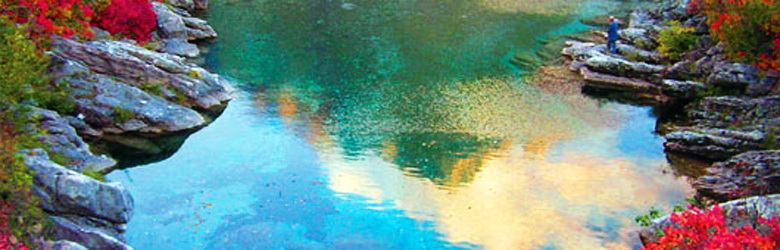
Jezerca Lake. 1200 m above the sea level. Represents the glacial lake, about 20 ha, with water as crystal, the surface freezing during winter. Forms the alpine ecosystem of the lakes. Hydrological research has value, didactic, aesthetic, tourist. Shkodër-Theth-road to the lake.
Muriqi cave. Situated near the village of Shkodra, Bratosh, 1567 m above sea level. Formed by carst in limestone, is 177 m long, 10-15 wide and 4-6 high, with a gallery and three extensions. It has tourist, geo-morphological, scientific values. It can be visited following the itinerary Prekal-Cukal.
The canyon of Grunasi. Located in the village of Theth, commune of Shalë, 700 m above sea level. Formed by the carst and the river of Thethi in limestone rocks, is about 1.8 km long, 40-60 m wide deep about 4-6 m. It has tourist, geo-morphological, scientific values. It can be visited following the itinerary Shkodër-Breglum road.
The field of Liqethi. Situated in the Mount of Cukali, 1200 m above sea level, near the village Lekgegaj, commune of Shllak. Represents glacial-carst cavity in the intersection of abruption, is 1.3 km long, 800-1000 m wide There are some minor forms of carst, herbal vegetation and a small lake which comes out during the snow melt. It has tourist, geo-morphological, scientific values. It can be visited following the itinerary Shkodër-Cukal road.
The cave of Katarakti (Waterfall). Located near Thethi village, commune of Dukagjini, 870 m above sea level. Known also with the names: "Where water breaks the neck”, Grunasi waterfall, and Water’s cave. Explored by the foreign speleologists and G. Uruçi. It is in limestone carst cave 170 m long, with galleries, wells, extensions of shrinking, siphon water. It has tourist, geo-morphological, scientific values. It can be visited following the itinerary Theth-monument.
The Cave of Liqethi in Cukal. Situated in Mount Cukali, 1200 m above sea level. Established by the lime carsti of Crete, during 75 10-12 m wide and 26-31 m high The cave has numerous concretions. It has tourist, geo-morphological, scientific values. It can be visited following the itinerary Cukal Prekal.
Hydro-monuments
The source of Vraka. Located near the Gruemirë village, 130 m above sea level. It is a vauclusian carst source in lithologic-technical contact limestone-molasses, 3-4 wide on 1.5 m deep. The water is used for irrigation and for supplying the surrounding villages. It has tourist, hydrologic, scientific values. It can be visited following the itinerary
Gruemirë Koplik.
The Sources of Kiri. located near the village, Pult commune, 400 m above sea level. It vauclusian source karst type, the technical-litologjik contact limestone-flisch. Its water comes out in a line about 800 m. The flux reaches 600 l / seconds. Here is the start of Kiri river. Hydrological research has value, teaching, tourism. It has tourist, hydrologic, scientific values. It can be visited following the itinerary Shkodër-Kir.
The Source Shtraza. Situated near the village of Theth, commune of Shalë, 900 m above sea level. The spring comes out in the same point where starts the river of Thethi. It has tourist, hydrologic, scientific values. It can be visited following the itinerary Theth-Koplik.
The recourses of Okoli. Situated near the village of Theth, near Thethi river, about 900 m above sea level. The Source comes in the contact limestone-schist, with length about 20 m. Creates an attractive environment. It has tourist, hydrologic, scientific values. It can be visited following the itinerary Theth-Koplik.
Thethi waterfalls. Situated near the village of Theth, the municipality saddle, about 900 m above sea level. Waterfalls above 30, with stunning views, especially on sunny, when formed rainbow. Hydrological research has value, didactic, aesthetic, tourist. Visited by the road-Theth Koplik.
Jezerca Lake. 1200 m above the sea level. Represents the glacial lake, about 20 ha, with water as crystal, the surface freezing during winter. Forms the alpine ecosystem of the lakes. Hydrological research has value, didactic, aesthetic, tourist. Shkodër-Theth-road to the lake.
Peja Lake. 1700 m above the sea level. Represents the glacial lake, over 10 ha, with tepid water in the summer, while in winter freezes on the surface. Koplik-Theth- Peak of Harapi.
Bio-monuments
The Flag Pine of Peja.
The Mgullit chestnuts-trees.
The Lime-trees in Lesniqe.
The tree of Kakia, Lekaj.
The Habitat of Salamandra.
The Forest of island “Franz Joseph”.
The Oak-trees of Minaqit, Domen.
The Plane-trees of Ramaj cemetery.
The Plane-tree of Hoxhe Dheu.
The Plane-tree of Tophana.
The T'plana Plane-tree.